Save this image free of charge
in 800 pixels for layout use
(right click, Save as...)
|
|
Ref : T02382
Theme :
Looking at Earth - Plains - Plateaus - Valleys (487 images)
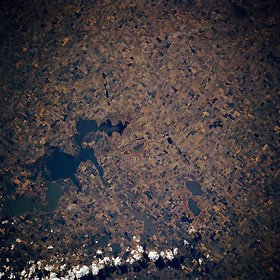
Title : Devils Lake, North Dakota, U.S.A. October 1985
Caption :
This east-southeast-looking, low-oblique photograph shows the agricultural lands surrounding totally enclosed, saline Devils Lake. Because of no outlet, the lake’s water levels, measured in terms of surface elevation, respond to changes in the climate—in cooler, wetter climates, lake levels rise; during warm, drier periods, levels decline. The surface elevation in 1880 was 1430 feet (436 meters); by 1940 it had dropped to 1401 feet (427 meters). With the decreased lake level, permanent settlement encroached further upon areas formerly occupied by water. Since 1940 water levels have gradually risen to present levels of near 1443 feet (440 meters), which have resulted in flooding of homes, highways, and municipal structures. Water surface elevation levels were near 1426 feet (435 meters) when this photograph was taken in 1985. Discernible north of the lake is U.S. Highway 2. The small city of Devils Lake on U.S. Highway 2 just north of the lake is barely perceptible.
|
|

